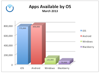
This is an exciting topic for me! I was late to the smartphone arena, but with the prompting of my geeky brother, I am 'ALL IN' and boy do I love it. I won't get into a discussion here about which OS (Operating System) is the best, it's simply personal choice. I chose to go with iOS, the Apple operating system. Therefore I own an iPhone, iPad and iMac. I like using the same operating system on all devices. In the beginning Apple was way ahead in the number of apps (applications, formerly referred to as programs). That has changed and it is predicted that the Android OS, a Google platform, will be the first to have 1,000,000 apps!
These smart phones we carry around are amazing feats of
science. The average smart phone today has more computing power than the first
NASA spaceship! Having said that…why not put all this power to work for you.
Everybody has their areas of interest, mine is forestry and real estate so I
love apps that help me with my work. There are a ton of apps out there, but I
wanted to share 4 with you. I have included not only a picture of the app but also an example.
AGRIplot
AGRIplot
allows you to plot any area on a map. Just walk around your property and add a
landmark point, or drag and drop pins anywhere on the map. AGRIplot will
automatically calculate the area enclosed by the points and provide the
distances between each point. You can add additional points of interest if you
desire. The app allows you to even take a picture at each point (corner) to
serve as a visual aid. From there you may email a PDF or KML version of the
plot information to your client. It now supports importing KML files used by Google Earth.
The App
The example
(Notice the acre calculation...54.32 acres!)
Skitch by Evernote
I have searched for
a nice app to help with annotating maps and photos….well Skitch is it! You can
annotate images and documents with arrows, stamps, shapes, text, and more. Skitch even allows you to mark up a PDF, snap
your screen, annotate a photo, or draw something new. Then, share your thoughts
and ideas with friends, family or co-workers. Skitch allows you to:
- ·
Snap
your screen, a webpage or a map
- ·
Zoom
and crop your images
- ·
Pixelate portions of an image to obscure
sensitive information
- ·
For
directions: Draw a path on a map to help someone find your picnic spot
The App
The example
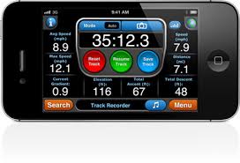
My Measures
My Measures is a
powerful application for storing and sharing object dimensions for iPhone and
iPad! My Measures is an industry standard
for real estate agents, engineers, carpenters, architects, auction sellers, construction
workers, landscapers and DIY.
It is
super easy to use. Just take a photo and add arrows, angles, text or notes. Now
the measures are stored and you have them always in your pocket wherever you
go. No more paper sketches in your wallet.
The App
The example
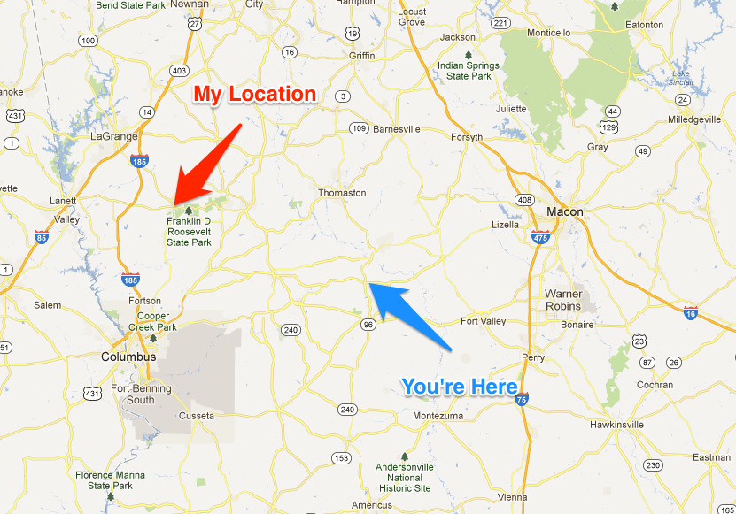
Motion GPS
This APP will blow
you away with so many features. This will turn your iPhone into a GPS unit to
help with hiking, biking, geocaching and so much more.
- ·
The #1
multi-sport application for the iPhone
- ·
Free
downloadable maps worldwide! Including MotionX Road and Terrain maps, and NOAA marine charts
- ·
Most
accurate iPhone GPS app
- ·
Allows
you to access street images or satellite images
- ·
Stores
up to 101 Tracks & 500 Waypoints
- ·
Facebook
and Twitter integration
- ·
Advanced
interactive stopwatch with live voice coaching.
The App
The example
Buy a new app and
impress your kids with your technical knowledge.
For
Information on Buying or Selling Land contact G. Kent Morris, ALC, RF
at (706) 457-0090