Sunday, July 21, 2013

Real Estate Trend Lines Moving in Positive Territory!


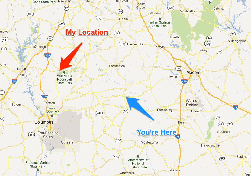
I generally write about “land” however I came across some positive statistics the other day furnished by the Georgia Multiple Listing Service. I am not positive, but I believe this is the largest MLS in the state. If not, send me a comment.  I am not representing that the data reflects what is going on in your market, but it is interesting to look at, trend lines are important! Although my primary interest is land brokerage and houses with acreage, the housing market impacts what I do and land price trends lag behind but follow home prices. WHY? Because as the housing inventory decreases, builders and speculators will begin buying land and build houses so they will have inventory to sell.

I wrote an article in April 2013 and I believe that the data helps bear my optimism about the real estate market.


Let’s take a look at the data:


 •    Median Prices rose 36 percent

•    Average Prices rose 26 percent  
•    New Listings increased .3 percent
•    Pending Sales were up 17 percent
•    Inventory Levels shrank 23 percent
•    Months Supply of Homes for Sale decreased 25 percent
•    Days on Market decreased 17 percent to 74 days
•    Percent of Original Price Received increased 3 percent to 95.5 percent


            Although I am not seeing land prices increasing yet, the activity is better and this will eventually translate into better prices!


If you are interested in Buying or Selling land, contact G. Kent Morris (706) 457-0090

Monday, July 1, 2013

Apps for the Real Estate professionals and landowners!


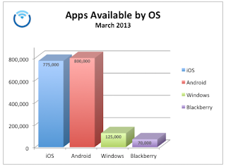
This is an exciting topic for me! I was late to the smartphone arena, but with the prompting of my geeky brother, I am 'ALL IN' and boy do I love it. I won't get into a discussion here about which OS (Operating System) is the best, it's simply personal choice. I chose to go with iOS, the Apple operating system. Therefore I own an iPhone, iPad and iMac. I like using the same operating system on all devices. In the beginning Apple was way ahead in the number of apps (applications, formerly referred to as programs). That has changed and it is predicted that the Android OS, a Google platform, will be the first to have 1,000,000 apps! 


These smart phones we carry around are amazing feats of science. The average smart phone today has more computing power than the first NASA spaceship! Having said that…why not put all this power to work for you. Everybody has their areas of interest, mine is forestry and real estate so I love apps that help me with my work. There are a ton of apps out there, but I wanted to share 4 with you. I have included not only a picture of the app but also an example.
  
AGRIplot
AGRIplot allows you to plot any area on a map. Just walk around your property and add a landmark point, or drag and drop pins anywhere on the map. AGRIplot will automatically calculate the area enclosed by the points and provide the distances between each point. You can add additional points of interest if you desire. The app allows you to even take a picture at each point (corner) to serve as a visual aid. From there you may email a PDF or KML version of the plot information to your client. It now supports importing KML files used by Google Earth.
The App


The example
(Notice the acre calculation...54.32 acres!)


Skitch by Evernote
I have searched for a nice app to help with annotating maps and photos….well Skitch is it! You can annotate images and documents with arrows, stamps, shapes, text, and more.  Skitch even allows you to mark up a PDF, snap your screen, annotate a photo, or draw something new. Then, share your thoughts and ideas with friends, family or co-workers.  Skitch allows you to:
  • ·      Snap your screen, a webpage or a map
  • ·      Zoom and crop your images

  • ·      Pixelate portions of an image to obscure sensitive information


  • ·      For directions: Draw a path on a map to help someone find your picnic spot


The App

The example


My Measures
My Measures is a powerful application for storing and sharing object dimensions for iPhone and iPad!  My Measures is an industry standard for real estate agents, engineers, carpenters, architects, auction sellers, construction workers, landscapers and DIY.  

It is super easy to use. Just take a photo and add arrows, angles, text or notes. Now the measures are stored and you have them always in your pocket wherever you go. No more paper sketches in your wallet.

The App


The example


Motion GPS
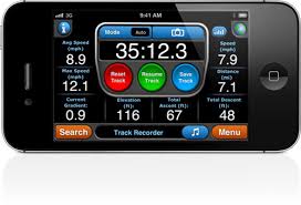
This APP will blow you away with so many features. This will turn your iPhone into a GPS unit to help with hiking, biking, geocaching and so much more.
  • ·      The #1 multi-sport application for the iPhone
  • ·      

Free downloadable maps worldwide! Including MotionX Road and Terrain maps, and NOAA marine charts
  • ·      

Most accurate iPhone GPS app
  • ·      

Allows you to access street images or satellite images
  • ·      

Stores up to 101 Tracks & 500 Waypoints
  • ·      

Facebook and Twitter integration
  • ·      
Advanced interactive stopwatch with live voice coaching.


The App
The example


Buy a new app and impress your kids with your technical knowledge.

For Information on Buying or Selling Land contact G. Kent Morris, ALC, RF at      (706) 457-0090

Saturday, June 1, 2013

Pond Management!

I caught a huge fish yesterday so I thought this would be a fun topic to write about!

Many landowners enjoy fishing, swimming, providing wildlife habitat, and relaxing beside recreational ponds on their property. Many more are considering building a pond. Here are some important aspects every future pondowner should consider.

Pond Site – Site selection is extremely important when it comes to building a pond. I suggest contacting your local Natural Resources Conservation Service (NRCS) office and they can assist in site selection, soil suitability, engineering survey, and design. They can estimate the cost of the earthwork, make quality control checks during construction, and provide information on other aspects of planning, design, and pond construction. Before you design your pond, consider the shape of the land, water supply, and soil type. If possible, consider more than one location, and study each one to select the most practical, attractive, and economical site.
Fertilization - Pretty complicated topic, so you might seek professional help here. The water should have a right color and hue which is an indication of phytoplankton bloom (start of the food chain). An unfertilized pond might yield 100 pounds of fish per surface acre whereas a fertilized pond might yield 300 - 400 pounds per surface acre. A pond can be fertilized using an inorganic granular fertilizer such as 20-20-5. A good rule of thumb... if you can see a shiny object 18 inches under the water, it might need fertilizing!
Pond Soil – Suitable soil is one of the primary factors in selecting a pond site. The soil should contain a layer of material that water will not seep through. Clays and silty clays are excellent soils for holding water. Sandy clays can work, but avoid soils that are well drained. To determine suitability, take soil samples at frequent intervals and have them analyzed. Again, the NRCS office can assist with this evaluation. Not evaluating soil strata properly could result in a pond that will not hold water, and that will make proper pond management very difficult. After all, you need water to have a pond!
Topography – Consider topography first when it comes to pond construction because it directly affects building costs and pond management. Put the pond where enough water can be impounded with the least amount of earth fill. A good site is usually one where you can build a dam across a narrow section of a valley and where the slope of the valley floor lets you flood a large area.  In simple terms you want a V-shaped drain (or hollow) instead of a U-shaped drain. Such sites are ideal and minimize areas of shallow water. Avoid large areas of shallow water because they become too shallow to use in late summer and fall dry periods, and they encourage undesirable aquatic plants (weeds).


When you do everything right, you get these kinds of results!!


Pond Water Supply – Water should be adequate, but not excessive, and may be provided by springs, wells, or surface runoff. For ponds where surface runoff is the main source of water, the contributing drainage area should be large enough to maintain a suitable water level during dry periods. This is critical. Keep in mind that deeper ponds do not necessarily produce more fish than shallow ponds. In fact, shallow ponds tend to be more productive, but ponds that are too shallow suffer the risk of drying under summer drought. The average pond depth should be about 4 feet. This lets fish forage on the bottom, even in summer, when low oxygen concentrations are common in deeper water, while maintaining enough depth to sustain the fish during drought.


Pond Management: Calculate Pond Size

The size of your pond is important when it comes to pond management. The size of your pond is the major factor that will determine what fish species to stock, the degree of management needed to maintain these fish, and how many fish you can remove each year. In short, it is important that you properly calculate pond size before you do anything!   Many pond owners of small ponds want bass, but small ponds are not suited for bass populations. This is primarily because bass harvest management in small ponds is especially difficult and unrewarding, as nearly all bass caught must be released to prevent overpopulation by forage fish. In small ponds, it is usually better to stock only catfish since they provide more fishing recreation, food for the table, and can be fed commercially prepared feed. Ponds larger than 1 surface acre are more suitable for multiple fish species. If these larger ponds  are managed and harvested properly, then you can expect many years of satisfactory fishing for all sport species, including largemouth bass. The choice is yours, but only if the size of your pond is adequate.


Pond Management Through Pond Habitat Structure

Creating better ponds and lakes for fishing and recreation takes active pond management. You can only expect to get out of a pond what you are willing to put into it. When it comes to creating better fish structure within a pond, various devices can be used in ponds to concentrate fish and improve fishing. The best results are obtained in ponds that are absent of natural cover such as stumps, tree tops, and aquatic vegetation. Fish structure should be located within casting distance of the shoreline, and you can even use floats to mark the location of your submerged fish structure.

FISH ARE BITING....GOT TO GO!!!

For Information on Buying or Selling Land contact G. Kent Morris, ALC, RF at      (706) 457-0090